


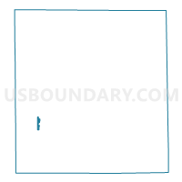
HARRISON 99, Elkhart County, Indiana
About
Outline

Summary
| Unique Area Identifier | 577010 |
| Name | HARRISON 99 |
| County | Elkhart County |
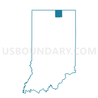
| State | Indiana |
| Area (square miles) | 0.36 |
| Land Area (square miles) | 0.36 |
| Water Area (square miles) | 0.00 |
| % of Land Area | 100.00 |
| % of Water Area | 0.00 |
| Latitude of the Internal Point | 41.53495010 |
| Longtitude of the Internal Point | -85.99920280 |
Maps

Graphs
Select a template below for downloading or customizing gragh for HARRISON 99, Elkhart County, Indiana


Neighbors
Neighoring Voting District (by Name) Neighboring Voting District on the Map
- HARRISON 84, Elkhart County, IN
- LOCKE 69, Elkhart County, IN
- OLIVE 91, Elkhart County, IN
- OLIVE 98, Elkhart County, IN
- UNION 72, Elkhart County, IN
Top 10 Neighboring County Subdivision (by Population) Neighboring County Subdivision on the Map
- Union township, Elkhart County, IN (6,134)
- Harrison township, Elkhart County, IN (4,435)
- Locke township, Elkhart County, IN (3,913)
- Olive township, Elkhart County, IN (3,068)
Top 10 Neighboring Place (by Population) Neighboring Place on the Map
Top 10 Neighboring Unified School District (by Population) Neighboring Unified School District on the Map
Top 10 Neighboring State Legislative District Lower Chamber (by Population) Neighboring State Legislative District Lower Chamber on the Map
- State House District 49, IN (69,174)
- State House District 21, IN (64,156)
- State House District 23, IN (60,512)